Say the key facts aloud. Then check.
📝 Two-Page Concise Written Study Brief
Coast Pilot 9 (13 Sept 2026)
Matched to the complete audio
Core local knowledge and Homer route description organized into 10 Coast Pilot categories. Focus on recalling the bold terms and connecting them into smooth verbal descriptions.
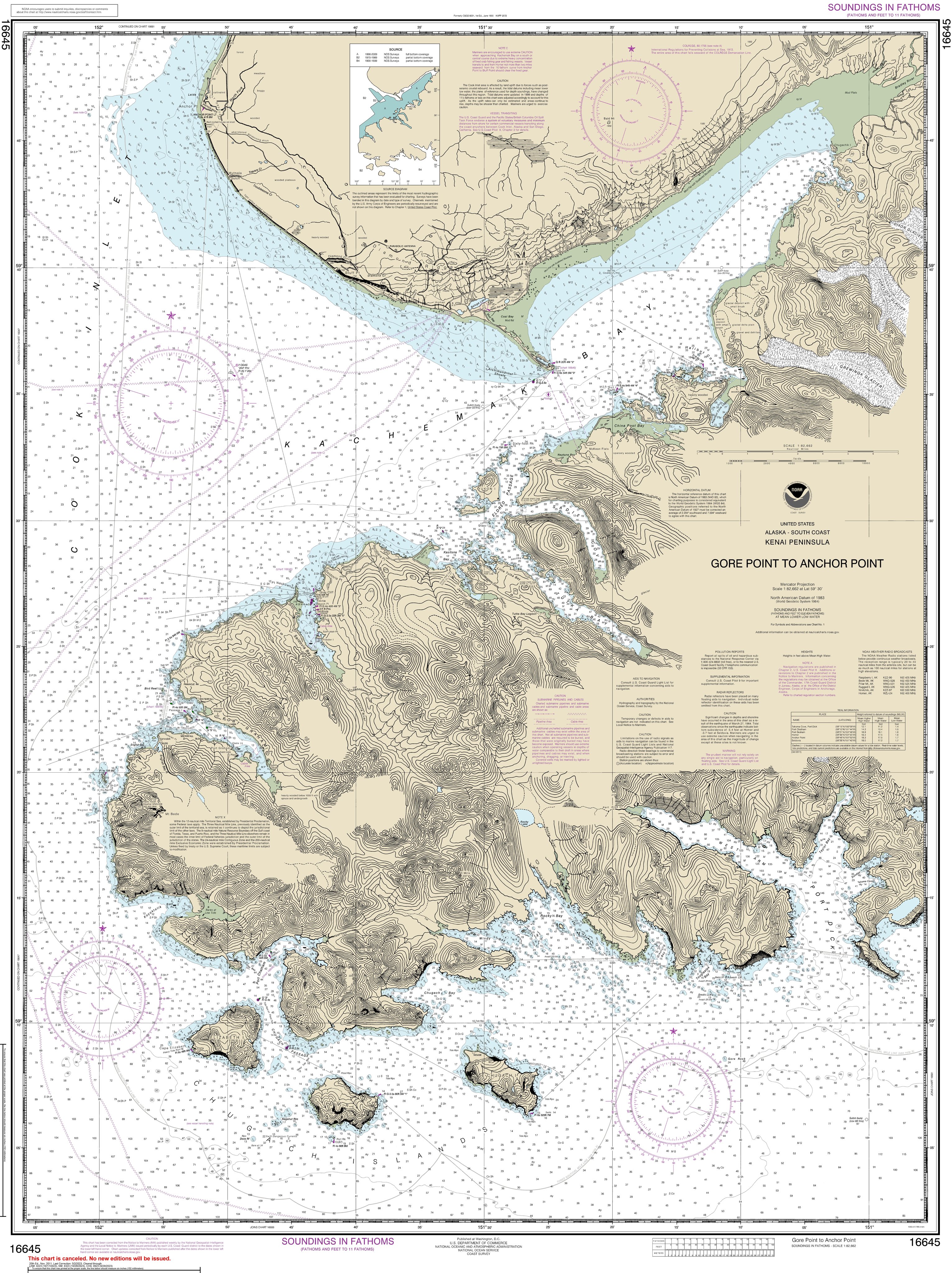
NOAA Chart 16645: Kachemak Bay & Homer Approaches
Your drawing practice: Reconstruct coastline, 10-fathom curve, critical soundings, hazards, cable areas, and 39 current Light List records clockwise from Anchor Point to Flat Island.
🧭 Clockwise Point Sequence (Stops 1 to 42)
42 places · Six scenes
NOAA 16645 · Chart Flight
🎨 Mnemonic Scene Keys & Illustrations
Active Recall Pegs
Six imaginary scenes cue the clockwise sequence. Tap a picture to enlarge it.
🗼 Aids to Navigation Transcription Table (39 Current Records)
Light List Vol VI
Your selected aids for chartlet placement and Light List transcription. The current Week 37 set has 37 physical/visual records plus the two AIS transceivers (Dangerous Cape and Homer ASTA), whose full MMSI numbers are included for the written Light List exam but are not shown as lamps.
Practice this list: names → full entries → whole area
| Aid Name | Characteristic | Height · Week 37 | Range | Structure / Remarks | Position · reference |
|---|
Continuous Spoken Route Description
All ten sections of the two-page written brief.
0:00 / 0:00
Transcript
Select a track to view its verbatim study transcript.
🗂️ Short prompts · Real answers
Short recall cards
⚡ Light List Trainer V2 • Active Recall Engine
Live USCG NAVCEN DecksMaster the 37 physical aids, rhythms, heights, ranges, and reciprocal obscured sectors with spaced-repetition drills, balanced practice quizzes, and timed pilotage exams.
⚖️ Factual Precedence & Source Comparison
Decisive Rule: Coast Pilot Governs
In accordance with pilotage examination discipline, where older candidate study notes or oral traditions conflict with the official publications, the more current Coast Pilot 9 (13 September 2026, pp. 205–212) governs.
| Topic | Older Candidate Notes | Current study reference |
|---|---|---|
| Homer tidal ranges | 29.5 ft is an older extreme-range figure, not the normal mean range. | About 16 ft mean; 18 ft great diurnal. NOAA station 9455558: 15.94 / 18.43 ft. The supplied Coast Pilot describes a large range without these constants. |
| Coal Bay Wreck | Not mentioned or omitted | Wreck covered 3 ft in shoal Coal Bay (Coast Pilot ¶1380). |
| VHF Communications | VHF 16 / 13 only | VHF 10 is primary working channel for Port Director & tugs; VHF 16 for Securite & distress; VHF 13 bridge-to-bridge. |
| Pilot Station & Notice | Informal radio call | SWAPA: 36 hrs advance notice, dispatch 90 min before, pilot boat 30 min out on VHF 10/16. Station is 1.0 NM south of Homer Spit Light 3. |
| Anchor Dragging Notification | Informal mention | Mandatory prompt notification to USCG Sector Anchorage or MSD Homer. |
| Gale & Storm Action Triggers | General weather caution | Gale (>34 kt): propulsion immediately ready, check position & UKC every 15 min, ready 2nd anchor. Storm (>48 kt): discuss scope, standby tugs, and departure to sea with USCG & SWAPA. |
| Dock Current Dynamics | General tidal notes | Pioneer: Eddy sets east on both flood and ebb (stronger on ebb). Deep Water: Flood sets on; ebb sets off (stronger). |
| Exam River Waypoint | Bradley River (outside chartlet) | Martin River is the river on the exam chartlet (Stop 10). Bradley River is outside chartlet boundaries. |
📥 Downloadable Study Resources
Offline Study & Anki
Use the Flashcards tab for immediate practice. These optional text exports are for offline study: